The Clarity Required for Your Most Complex Decisions
As Moultrie continues to expand its footprint as a vital industrial and agricultural center within the Coastal Plain, the demand for flawless spatial data has never been higher. For the engineers, project coordinators, and land managers of Colquitt County, legacy surveying techniques are often too sluggish to accommodate modern construction schedules. Moultrie Ag Drones represents a paradigm shift in how regional data is harvested. We provide more than just "aerial views"; we deliver high-integrity geospatial intelligence that serves as the definitive source of truth for your project’s critical milestones.
Our methodology is designed to solve the logistical headaches of South Georgia surveying: the high costs of manual labor, the safety hazards of active job sites, and the inefficiency of manned aircraft. By deploying a sophisticated fleet of Blue UAS platforms outfitted with metrically precise sensors, we can document thousands of acres in a single operational day. Whether you are calculating inventory for a local aggregate facility or plotting a multi-mile utility expansion through the Coastal Plain, we provide seamless, CAD-ready data that fits directly into your professional GIS environment.
The Blue UAS Security Standard
In a world of increasing digital threats, the confidentiality of your site data is our top priority. Our entire fleet consists of Blue UAS Certified systems, meaning they have cleared the most stringent cybersecurity and supply chain audits required by the U.S. Department of Defense. For managers of critical infrastructure in and around Moultrie—including regional power grids, water systems, and telecommunications—this certification guarantees that your sensitive data remains protected from the point of capture to the final hand-off.
Volumetric Precision: Mastering Inventory Control
For the industrial and mining operations throughout Colquitt County, knowing your exact inventory levels is a financial mandate. Manual stockpile measurements are not only time-consuming but introduce unnecessary risks to personnel navigating steep slopes and unstable ground. We eliminate the guesswork and the danger. Our 61MP photogrammetry sensors capture hyper-detailed imagery to generate high-density 3D models of your entire inventory.
Utilizing PIX4Dmatic—the gold standard for large-scale volumetric computation—we produce auditable cut/fill reports with centimeter-level precision. For accounting departments and site managers in Moultrie, this means monthly reconciliation is transformed from a logistical burden into a streamlined digital process. Within 24 hours of flight, your site is converted into a fully measurable asset, accessible and shareable across your entire organization.
LiDAR Solutions: Mapping the Forest Floor
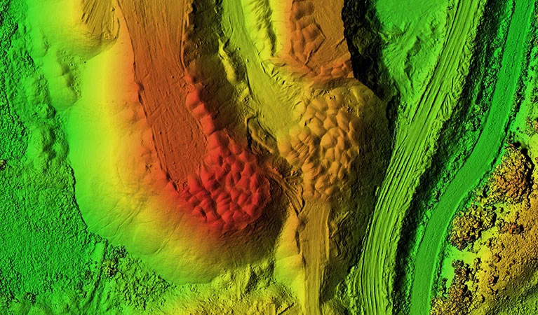
The Georgia Coastal Plain is defined by its thick timber stands and dense pine canopies, which typically render standard aerial photography useless for ground-level mapping. Engineering projects in Moultrie require a clear, unobstructed view of the terrain hidden beneath the brush. Our LiDAR (Light Detection and Ranging) services are specifically engineered for these South Georgia conditions. We utilize the Riegl miniVUX-2UAV, a premier sensor renowned for its vertical accuracy and penetration capabilities.
By emitting millions of laser pulses every second, our LiDAR systems "see" through the most stubborn Moultrie vegetation, reflecting off the soil to create a high-fidelity "bare earth" Digital Terrain Model (DTM). For developers planning new commercial tracts or engineers designing complex drainage systems on flat Coastal Plain topography, this data is indispensable. Our LiDAR surveys provide absolute vertical accuracy within one inch, uncovering topographic nuances that traditional methods simply cannot detect.
Large-Scale Operations & Multi-Aircraft Coordination
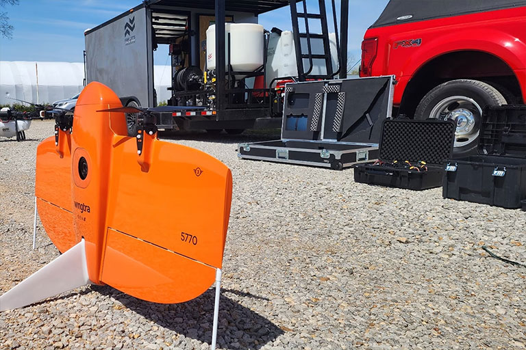
Scale is the ultimate challenge for infrastructure development in the region. Standard drones often lack the flight time to cover massive parcels, and manned flights are cost-prohibitive for frequent monitoring. We deploy the WingtraOne Gen II, a fixed-wing VTOL (Vertical Take-Off and Landing) aircraft that can map over 700 acres per flight—ten times the capacity of a standard quadcopter. For the largest developments in Colquitt County, such as expansive industrial parks or vast agricultural tracts, we deploy multiple crews and aircraft in parallel.
This synchronized data collection allows for the mapping of several thousand acres in a single day without a loss in resolution. Our integrated Post-Processed Kinematic (PPK) technology ensures every data point is geotagged with centimeter-level precision, drastically reducing the time spent on manual ground control. This results in a faster project timeline and a smaller operational footprint on your site.
3D Digital Twins & Site Modeling
Evolve your project visualization from flat blueprints to photorealistic 3D digital twins. It is often difficult to communicate the spatial complexity of a large-scale project through 2D maps alone. We generate immersive, measurable 3D property models that allow Moultrie stakeholders to visualize, analyze, and present their projects with unprecedented clarity.
By blending nadir and oblique imagery, we create high-textured 3D meshes and point clouds that serve as an "as-built" digital record. This is a powerful tool for monitoring construction milestones, conducting architectural shadow analysis, or marketing high-value real estate. For local developers, a digital twin offers a verifiable historical record of site changes, ensuring that every phase of construction aligns perfectly with the original design specifications.
Technical Accuracy Metrics
Horizontal Accuracy
1.0 cm
PPK Enabled Precision
Vertical Accuracy
< 2.5 cm
LiDAR Terrain Data
Ground Sampling Distance (GSD)
0.7 cm/px
MAP61 Full Frame
Managed Workflow
Your dedicated Moultrie Project Manager oversees the entire technical workflow, from sensor selection to data processing in Pix4Dmatic. We deliver actionable results in the precise formats your engineers require, including DXF, DWG, LAS, and GeoTIFF files.
Request Technical Scoping